


Driftless Stream Corridors - From Past to Present
- Jason G. Freund

- Jun 6, 2022
- 8 min read
Updated: Jun 7, 2022
Relative to reconstructing the vegetation of the Driftless, establishing a clear picture of what the streams and their riparian zone were like is quite a bit more difficult. There are some things we do know with certainty, however. Stream valleys have been filled with cultural sediments from late-1800 and early-1900 agricultural practices that were poorly suited to the steep slopes of the Driftless landscape. Cultural sediment as it is called has far reaching effects ranging from having an effect on the amount and nutrient content of sediments responsible for the Gulf of Mexico dead zone to changing the trout streams of the Driftless into the entrenched streams we see today. Driftless valleys of today are little like Drifltess valleys before agriculture and forest cutting forever changed them.
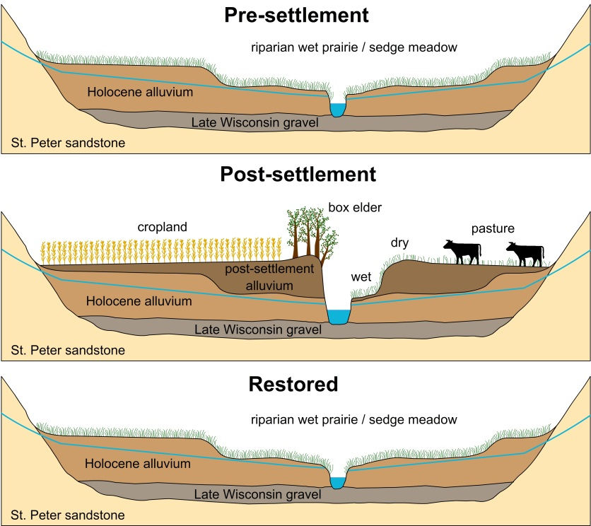
This is the standard model for Driftless streams - chances are pretty good you have seen this image or one something like it before. The idea is that Driftless streams flowed through wet prairie / sedge meadows. The soil surface was close to the groundwater and this prevented trees from growing - a dynamic we see today in many wet prairies. These wetland valleys allowed significant recharge of groundwater and buffered streams against floods. Then cultural sedimentation, labeled as post-settlement alluvium, eroded from the hills, covered the valley bottoms with anywhere from a foot to 20 or more feet of sediment - this was the result of agricultural practices poorly suited to the soils and slopes of the Driftless Area. This post-settlement alluvium - alluvium simply refers to sediments moved by flowing water - drastically changed streams and created the entrenched, highly-modified streams we see today. And the last panel of the figure shows what a restored stream valley would look like. Examples of such restoration are rare because it is expensive to move the tons upon tons of sediments out of the valleys and back to the hills and plateaus that they came from. The East Branch of the Pecatonic River is the only example I am familiar with where cultural sediments were hauled from the valley. We very rarely restore streams or their valleys but we often improve or manipulate stream habitat.

I have a feeling - but I do not have great data to support that feeling - that, much like the plateaus and slopes, there was probably a good bit of variation in the vegetation of Driftless Valleys. The model above where the pre-settlement valley was a wet meadow and covered in sedges and grasses is probably true for most of the Driftless. However, I do suspect that there was some variation, particularly in the more heavily forested watersheds like the Kickapoo. However data supporting this are lacking and without data we are left to suppositions which are rather imperfect at best (loony at worst).
Cultural Sediment
Cultural sediment is really the story of Driftless valleys. I think it is rather difficult to understand how much sediment was deposited in the valleys of the Driftless. In the headwaters, estimates are typically a foot to maybe three feet (0.3 to 1 meters) and that amount increases as we move downstream. In places, there are several meters (2-5 meters, 6 to 16 feet) of over-bank sediments. Most of the sediment was delivered from the early settlement through the Great Depression. After the Great Depression and watershed measures implemented by the Soil Conservation Service (now the NRCS) and others, the amount of sediment delivered to the valleys was greatly decreased - but the damage had already been done.

From Trimble 1999
What I find interesting about this figure is that the efflux to the Mississippi River had remained nearly constant over this entire time. Today most of that efflux is from the streambanks. And to look at the sources, by 1975, they have declined to approximately 25% of what they had been during early European settlement.

From Trimble 1999
The above figure show how and when the lower part of a watershed had been altered. Quite clearly, most of the deposition occurred between1904 to 1938. In this reach, nearly 4 meters of sediment filled the valley. It shows too how the stream channel has aggraded to its present level, well over a meter above the historic valley floor.

From: Trimble and Lund 1982.
To tie those two figures together, this one shows how valley alluviation varies spatially. The most obvious trend is that the lower valley received the bulk of the cultural sediment. Lower ends of tributaries and where they entered the main river also increased deposition.

From: Trimble and Lund 1982.
And lastly for these sets of figures, streams are increasingly acting more similar to their pre-settlement conditions in terms of stream power and the parameters that affect stream power - velocity, depth, and slope. Stream power can be thought of as a measure of what and how much material streams can move and it is often used to calculate stream competency, a measure of the largest particle able to be moved by a stream. What is evident in this figure is that today's stage 4 streams have mean velocities, depths, and stream powers similar to pre-settlement streams. However, as established above, today's streams flow through valleys that have been greatly aggraded. The same but much different...
Vegetation
Information about vegetation that is specific to stream corridors is harder to come by. Certainly today, grazing and other agriculture is the dominant land use in Driftless valleys. Were trees more common in the valleys before European settlement? There really is not much evidence to suggest that is true but the data are generally not at a scale that is useful for answering that question. But witness tree accounts - which one might assume would favor trees that grow in valleys with relatively few trees - are dominated by oaks. Trees common in riparian zones - black willow, ash, cottonwood, and boxelder were very uncommon as witness trees. (See the previous post, What Did the Driftless Look Like, for a more in-depth examination of historical vegetation.)

Records from the public land survey system (PLSS) of the mid-1800's shows similar rarity of trees we associate with riparian zones. Searches looking for more detailed information return few results about Driftless Area riparian zones and their vegetation. Belby et al. (2019) is probably the most definitive resource and they make few mentions of forested buffers along streams. Mentions of beavers or of a number of riparian trees are generally lacking though some early surveyors did write of oak forested valleys.

While we can't necessarily recreate pre-settlement vegetation in the valleys, modern land use tends to ebb and flow with the economic realities of farming. Conservation Reserve Program (CRP) took a lot of highly erodible lands out of production in the Driftless in the mid-1980's through the 1990s. However since then, Wisconsin has been a leader in taking CPR land out of the program and returning that land to agricultural uses. A post, The Re-Birth of The Driftless, digs into the changes to the Driftless and the challenges we will face. As commodity prices rise faster than CRP payments, we can expect to continue to see more row crop agriculture in valleys.
Current Valleys and Stream Corridors
Today's valleys are dominated by agricultural land use however the 2018 flood did a bit to change land use in the valleys. I see a number of pastures that were once grazed that today are not being grazed as farmers, I assume, got tired of the time and expense associated with putting up new fences that are likely to come down in the "next big one" which are occurring at an alarmingly rapid rate. But many of the most popular streams still flow though rather heavily grazed riparian corridors. In part because anglers enjoy the easy walking and in part because it is a very common land use in Driftless valleys. These cool season grasses are generally not deep rooting and lack the holding power of the native prairie soils. Stream work helps keep the soils from moving downstream and into the Mississippi River.

Opinions vary quite wildly on habitat restoration, manipulation, improvements, or whatever you want to refer to streambank work as. At its best, stream improvements aid with flood resiliency, reduce the amount of sediment and associated nutrients carried by streams, and improve the quality of habitat for trout and other species. At their worst, it is an expensive and, at times, short lived band-aid to try to undo the history of the valleys and they look unnatural. Much of the work is in grazed pastures which themselves are quite unnatural. The same work done in places without grazing look much more "natural". Rip-rap along the banks that deters cattle from damaging the banks as do cattle crossings help protect stream banks. And much of the work has been in places where boxelders have invaded the riparian zone and resulted in entrenched and rather gnarly streams with high rates of erosion.

Often times these projects get maligned as manicured and golf course-like, and I get it, unnatural looking projects are unsightly. But the valleys they are in are anything but natural. We tend to get worked up about things that do not really matter all that much in the larger picture. Stream improvement projects are a part of what brought the Driftless back to what it is today. That gets lost in the arguments over trees vs. grasses, techniques that allow streams to move and those that lock them in place, and other arguments how manicured / natural the projects look. Yes, a project done in a continuously grazed pasture that has been altered by feet of cultural sediment is not going to look natural - but neither is the landscape which it is in. That point often gets lost in the discussion.
My take, the more we can do to reconnect streams to their rather altered floodplains, the better. It would be great to have a buffer law that helped protect streams but that is a seemingly nearly impossible ask. Sloping back banks and minimizing the damage that cows can do is a good start. Far from perfect, but a good start. And it is about more than just the fish - with the rains we have had, passing floods is a significant issue to many more people. It is about trying to do something about the Gulf of Mexico's dead zone. It is about doing what you can do in a greatly altered landscape to improve habitat for fish and other species and prevent against the ravages of increasingly severe rainfall and flood events. It is not perfect, neither is the landscape in which we inhabit.
For the previous post on vegetation on the Driftless Area: Link.
Literature Cited
Belby, C.S., L.J. Spigel, and F.A. Fitzpatrick. 2019. Historic changes to floodplain systems in the Driftless Area, Pages 119-146 in Carson, E.C., J.E. Rawling III, J.M. Daniels, and J.W. Attig, editors, The Physical Geography and Geology of the Driftless Area: the career and contributions of James C. Knox. Geological Society of America Special Paper 543. The Geological Society of America. https://doi.org/10.1130/2019.2543(07).
Trimble, S.W., 1999. Decreased rates of alluvial sediment storage in the Coon Creek Basin, Wisconsin, 1975-93. Science, 285(5431), pp.1244-1246.


The best solution is to capture the fertilizer (phosphorus and nitrogen) from the ridge farmer's fields is with dams on the ridges before gullies going down into the valley's streams and rivers and with wetlands between the valley farmer's fields and the streams and rivers in the valleys.
Please read this article, Nutrient pollution from nitrogen and phosphorus reduces streams' ability to support aquatic life. https://www.eurekalert.org/pub_releases/2015-03/nsf-npf031015.php
How many of the mayfly nymphs in our Driftless streams eat the fertilizer (phosphorus and nitrogen) that comes off the farmer's fields? Yes, the mayfly nymphs eat the leaves, seeds, branches and timber from the riparian zone trees. The fertilizer (phosphorus and nitrogen) from the farmer's fields causes algae bloom in our Driftless streams and rivers. The lack of leaves, seeds, branches, and timber entering the Gulf of Mexico takes away the food chain of all the aquatic inhabitants in the Gulf of Mexico.
Scientific Fly Angler, I would like to take you on a field trip to the Coon Creek Watershed and educate you on what the watershed was like in 1950. Hopefully, I can enlighten you on some history from a native Coon Creek resident that lived along the Rullands Coulee Creek as a youth. All of your references are incorrect in your blog and your ASSUMED conclusions leads the totally ignorant youthful DNR Personnel and totally ignorant youthful TU Personnel to wrong information.
Do you have any idea on what would feed the whales in the Arctic Ocean if the rivers flowing North would have dams built that would restrict all the leaves, seeds, branches, and timber from flowing into the Arctic Ocean? Yes, there would be a dead zone in the Arctic Ocean like in the Gulf of Mexico.