


Finding Clear and Cold Water
- Jason G. Freund

- Apr 24, 2023
- 9 min read
Clean, cold water - it's what trout crave!
I hear or read on social media all the time that anglers think there will not be fishable water after that recent storm. And often they think its effects are going to last for days. I suppose I should shut up and continue to let them think this. There is almost always clear, cold water somewhere, you just have to be willing to look, and use your knowledge and resources to find it. No question, it will often put anglers outside their comfort level, often on smaller streams than they prefer to fish or places they have never fished before - which I do not see as a bad thing.

There are some simple tips to find clean and cold water - head upstream and to tributaries as they will clear faster and generally stay colder in the heat of summer. The general rule is that larger streams take longer to get turbid but will stay turbid for longer. And larger rivers will (generally) be less dominated by spring flow and thus warmer. A great way to stay on cold water is, of course, to carry a thermometer. But the observant angler is making notes in the winter of stream reaches that stay free of ice, particularly in the coldest parts of winter. During the growing season, I am looking for watercress.

Not all tributaries or headwaters are created equal. Watersheds with little agriculture will get less muddy and clear faster. Watersheds with continuous (non-rotational) pastures and particularly with a lot of row crops - especially corn - will get muddier and stay muddier for longer. If those corn fields are on slopes, expect clarity to the worse for longer. Nothing Earth-shattering here I know. Geology also plays a role. I have not fished Castle Rock Creek in a few years but the joke was always that high humidity got the creek muddy and the reality was not far from reality. It certainly had a lot to do with agriculture in the watershed but geology and soils probably had a bit to do with its near chronic turbidity too.

This post will be posted well after the event but after some pretty heavy rains from August 6th through the 8th of 2022, I headed out to two of the watersheds nearest to me - Coon Creek (Timber Coulee) and Mormon Coulee Creek and did a bit of fishing but mostly I scouted to get a better idea of how different reaches responded to the rainfall we had. I was in La Crosse, Monroe, and Vernon Counties.

Before we get there - there are a lot of resources to help you understand how different watersheds are likely to respond based on their size, land use, and other factors. One tool I have come to use a fair bit is ModelMyWatershed.org which is a GIS (geographic information system) that allows you to do many different things but mostly I use it to delineate a watershed from a map. It then returns a ton of information: the size of the watershed; the length of streams and their orders; land use, soils, number of different animals in the watershed.

From this you can see things like there are 201 square kilometers (77.6 square miles) of land upstream from the Highway 14 bridge at Coon Valley that drain into Coon Creek. Deciduous forest is the dominant land cover with pasture/hay and cultivated crops (row crops) the next two most common land uses. ModelMyWatershed allows you to dig a little deeper into the other stats as well. One caveat, I think it is really accurate for some variables - watershed area, soil types, land slope - and probably less accurate and up-to-date for other variables - land use, animals - which are more human-created variables. But it is a good tool to get you started in understanding different watersheds.

The Mormon Coulee watershed was delineated from the park in Shelby and is quite a bit smaller - 84 square kilometers (32.4 square miles). Not surprisingly due to the smaller watershed area, Mormon Coulee has many fewer tributaries. It was also significantly more turbid throughout its length than was Coon Creek and its tributaries - we will get into why I think that is likely the case later.

Another great resource is are the USGS stream gage network. If there is a problem with using USGS data, it is for many places, there are simply not enough stream gages to really have a good idea what is happening with stream flows. The data are great if your interest is knowing if the Kickapoo or Wolf Rivers are at the right level for your canoe or raft trip or if they are at a level for comfortable wading. If you want to know if Coon Creek or Mormon Coulee are going to be muddy, there just is not a station that is close enough to be very informative.

The La Farge gaging station on the Kickapoo River is probably the most useful one because of its long history - a record that goes back 83 years. This means that the mean daily statistics (the triangles in the hydrograph) are much more accurate. When I looked at the Ontario gage, the median is based on 2 years of data and reflects that there was a larger flood the same time last year. The 2022 event I scouted was "a nice little flood event" in most places. Though from the rainfall map (above), it looks like some areas got hit much harder than others. In fact I ran into a couple from Madison that started in Grant County (far southwest Wisconsin) and found everything to be pretty turbid. Maybe they had been fishing Castle Rock Creek...
My Journey
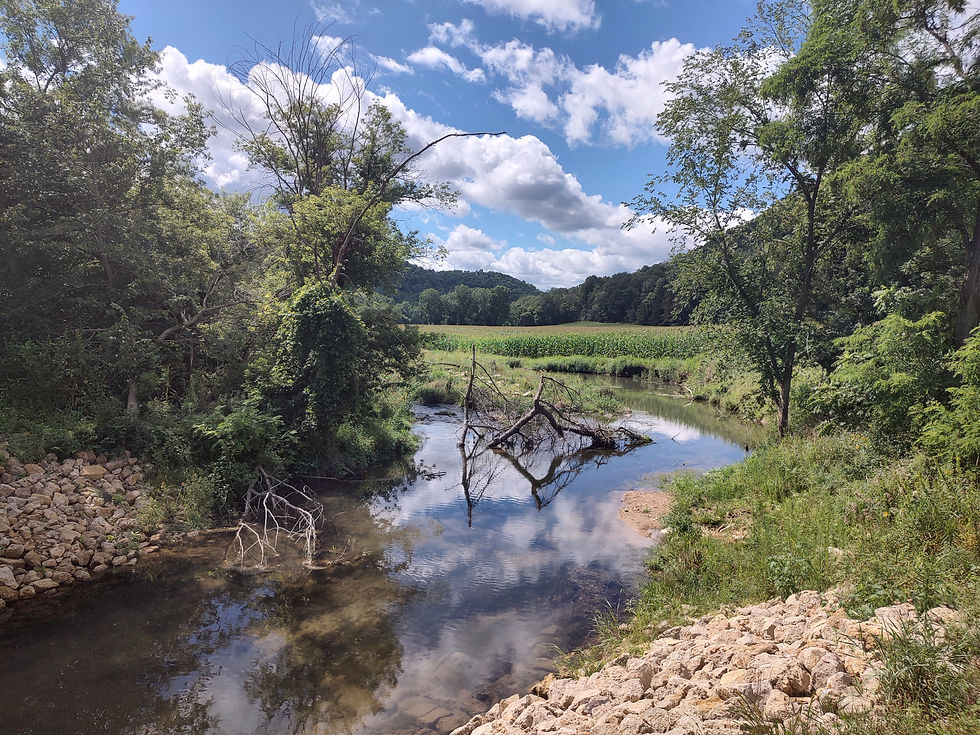
Coming in from La Crosse, from the West, I came over the Ten Mile Hill and dropped into Coon Valley, crossing the Highway 14 bridge looking at the stream of the watershed I delineated and have an image of above. It was immediately evident that Coon Creek was a bit high and a lot muddy. This is always my first view of what is going on in the watershed.

As I moved up along Highway P, I crossed the tiny stream that runs along Highway 14 and it was pretty clear with just a bit of tint to it. The next stop was the Neprud Property where Spring Coulee joins Coon Creek. Coon Creek is a sizeable stream by this point and, as expected, it was turbid - probably right on the edge of being fishable.

Continuing up Highway P - the troutiest county highway in Wisconsin (do you have other suggestions?) - I crossed Spring Coulee which was a bit turbid due to some bare ground around the Wisconsin DNR habitat improvements upstream.

I continued up the county highway and crossed Coon Creek again, it was still turbid but less so than at the Neprud Property which shows how much Spring Coulee contributed to Coon Creek's turbidity. From here, the next stream is a little stream that runs along the smaller county highway which was gin clear - but at an average width of less than 3 feet, it is probably not everyone's cup of tea. I am a bit fortunate, I suppose, as I generally prefer fishing water smaller than most people care to fish. Part of that is that it gets me away from crowds but as a self proclaimed dry fly snob, I find those are the places where trout are more often "looking up".

Next on the journey is crossing Bohemian Valley Creek not far from its junction with Timber Coulee where the two come together to form Coon Creek (some maps label Bohemian Valley as Coon Creek). I continued heading up Timber Coulee looking at the stream at the Bob Jackson section and it was just the right shade of turbid.
Anglers can benefit from a little bit of turbidity. It often has the fish feeling a little bit more protected from predators and often allows us to get a bit closer to the fishes. And the slightly increased flows may knock off a few more nymphs and make it a bit tougher for scuds to hang on or to swim. Couple a little bit of turbidity with overcast skies and you probably can not find conditions more in the angler's favor.

From here, I continued upstream on Timber Coulee with the goal of getting up to the headwaters to see what things looked like along the journey. It had gotten pretty clear above Bohemian Valley which was kicking in a good bit of turbidity. All of it was fishable - so I fished a bit and caught a few on terrestrial dry flies.

On the way back downstream, I checked out a few other places and fished a bit along a recently improved reach I had not yet walked. I was being a little lazy and didn't even put on waders. The trip was more about scouting than fishing but the open access gave me a chance I have not yet had. Recently completed habitat projects are like a magnet for anglers, it seems. I checked out the new work, making a few casts here and there, catching a fish now and again.

One thing I noticed when I got to an old favorite spot was that the work lowered the stream level at least half a foot. Many of our streams have been aggrading over time - meaning that sediment delivery and deposition has increased the elevation of the stream.

On the return trip back downstream, Bohemian Valley had just the right stain but someone was fishing upstream. Downstream a rather impressive bull was the first of the cattle that I saw and that made that spot a big huge NOPE!

Spring Coulee was actively being worked on by the Wisconsin DNR habitat crew out of La Crosse so it was rather turbid and not at a clarity I would fish.

I traveled further down the watershed, below Coon Valley where the "creek" gets pretty large. As expected, the turbidity was more than I would care to fish.

The point of that little written journey through the Coon Creek is not to hot spot. It is certainly one of the best known and most heavily fished watersheds in the state. I did not give away your secret spot - which is not to say that there are not spots in the watershed that are fairly decently well kept secrets (but hardly unfished). My goal was to share about scouting a watershed and what to look for (more on that at the end).

My scouting journey then took me to Mormon Coulee which for as close as it is to me, I do not fish that often. There is no good reason for this other than I prefer the water a bit further east which is only 10 more minutes away. It is a very productive stream - hence the 10 fish, no size restriction bag limit.

Compared to Coon Creek - particularly given their differences in drainage areas - Mormon ran muddier from top to bottom. There was certainly fishable water on Mormon higher up but even this was a bit turbid whereas the upper reaches in the Coon Creek Watershed were near gin clear - maybe dirty gin Martini clear. Mormon Coulee's valleys are wider and flatter than most in the Coon Creek watershed and thus there is more row crop (corn and soybean) agriculture. And its headwaters got a little more rain.

The Larger Points
Anglers need to be a little flexible following a storm event but those that are willing to move upstream, to move to watersheds they maybe don't fish very often, are very likely to find fishable water. For many anglers, this means moving a bit out of their comfort level. Fishing smaller streams, maybe in tighter quarters than you might prefer - what I like to call "roll-casty" water. This advice is much the same for the angler looking for colder water when the larger streams are getting too warm.
There are a lot of variables so "rules" are hard to come by. First, storms are almost always variable in how rain is delivered. A quick look at the rainfall map shows that within 30 miles or less, differences of rainfall were several inches.

And watersheds are different in how they handle rainfall. I am looking for watersheds with an abundance of prairies, fallow lands, and rotational grazing and a dearth of row crops and continuously grazed pastures. How streams and their watersheds handle rain changes throughout the season. The same rain in April, before much vegetation growth, would probably have made more unfishable water for longer. By early August, there is a ton of vegetation to intersect the rain.

Get to know a watershed or two and know how they and their individual streams respond to rainfall and flood events. This was a fairly minor flood event so the stream cleared pretty quickly. I was out less than six hours after the last of the rain. It was a long event with several breaks in the storms. The same rainfall over a shorter period of time would have had a different effect on the streams.
An angler that is willing to move upstream, maybe into places where the casting is not as easy and as open can almost always (yes, there are exceptions) find clear and cold water and find fish. Rarely is the answer not to go fishing - though I have no problem if you stay home and leave me with that perfectly "just a little cloudy" stream.


Did you isolate the source of the mud in Mormon Coulee? Can stream restoration work correct the problem? In my youth I can remember a long, high sandy road bank along a county road close to a tributary of Timber Coulee Creek that would pollute the tributary every time after a good rainstorm.
I don't mind some color in the water. If I can see my feet in calf-deep water, I'll fish it, I have sometimes resorted to a big black streamer in dirty water and caught the biggest fish of the month.
It's good in summer to check the water temps after a rain. I know of a stream that warms considerably after a hot summer thunderstorm, and the fish move upstream toward the springs to find comfortable water.